Truso Valley: Kobi to Zakagori Fortress
A long, gentle valley walk from Kobi along the young Tergi river past travertine terraces, mineral springs, a bubbling lake and abandoned Ossetian villages to the Zakagori fortress. About 22 km return and under 500 m of climbing, 6 to 7 hours.
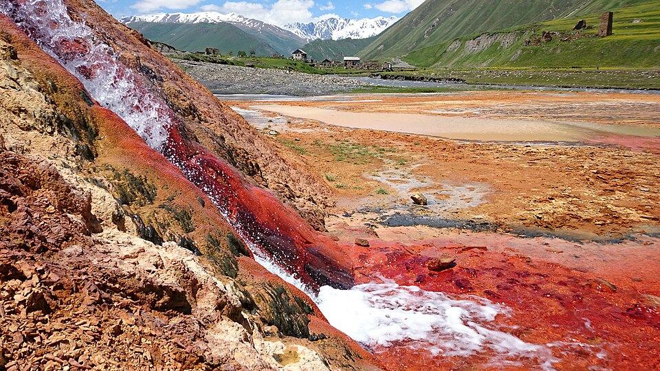 Truso ValleyPhoto: Nino19682210, CC BY-SA 4.0
Truso is the easy, open walk of the Kazbegi area. The valley runs west from Kobi, close to the Jvari Pass, following the first few kilometres of the Tergi river. The floor is wide and almost level, at about 2,000 to 2,250 m, with steep grassy walls on both sides and snow on the ridges until early summer. There is no single climb, only a gradual rise over 11 km.
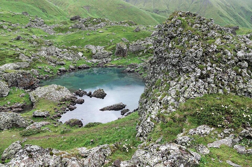
What makes it special is the geology and the empty villages. Carbonated springs have built orange and white travertine terraces near the entrance, and further in a small lake fizzes with gas from below. Ketrisi and the other hamlets were home to Ossetian families until the 1990s and are now mostly stone shells. At the far end Zakagori fortress sits on a rock spur above the river, with the boundary of the occupied Tskhinvali region just beyond it.
You can walk the whole valley, drive part of it by 4x4, or mix the two. In a car with high clearance the track is passable to near Ketrisi in dry weather; on foot the full out-and-back is a long but undemanding day.
Highlights
- Travertine terraces in rust, cream and white near the valley mouth
- The fizzing Abano mineral lake
- Empty stone villages and towers at Ketrisi
- Zakagori fortress on its rock above the Tergi
- A flat, open valley walk at over 2,000 m with almost no climbing
Trail facts
Last checked Oct 2026 by the Maspindzeli team. Mountain conditions change: ask us before you go.
Is this right for you?
Three quick questions for a friendly second opinion. Nothing is sent anywhere.
Stage by stage
| Day | From → to | Distance | Up | Down | Hours | Highest |
|---|---|---|---|---|---|---|
| 1 | Valley entrance below Kobi → Mineral springs and travertine terraces | 3 km | +60 m | −40 m | 0.75-1 h | 2,050 m |
| 1 | Travertine terraces → Ketrisi and Abano | 5 km | +150 m | −20 m | 1.5-2 h | 2,150 m |
| 1 | Abano → Zakagori fortress | 3 km | +100 m | −10 m | 1 h | 2,250 m |
| 1 | Zakagori fortress → Valley entrance below Kobi | 11 km | +150 m | −390 m | 3 h | 2,250 m |
01Kobi to the travertine springsValley entrance below Kobi → Mineral springs and travertine terraces · 3 km · 0.75-1 h
From the Military Road a dirt track drops to the Tergi and crosses to the north bank. Follow the river upstream into the gorge, which narrows briefly before opening again. The first mineral deposits appear on the slopes to the right, stained red and cream. The ground around the springs is soft and crumbly, so look from the edge.
01Springs to Ketrisi and the Abano lakeTravertine terraces → Ketrisi and Abano · 5 km · 1.5-2 h
The track stays close to the river through broad meadows where cattle graze. Ketrisi appears on the far bank with its ruined towers, and soon after, near Abano, a small pool bubbles constantly with carbon dioxide. Stop for lunch here if you want a shorter day.
01Abano to Zakagori fortressAbano → Zakagori fortress · 3 km · 1 h
The valley turns slightly and the fortress comes into view on its spur, guarding the old route over to the south. You reach the border police post shortly before it. Show your passport, look at the walls from the track, and turn back here.
01Return to KobiZakagori fortress → Valley entrance below Kobi · 11 km · 3 h
Walk back down the same track. The afternoon wind usually blows up the valley into your face, and the final climb from the river to the main road is the steepest part of the day.
Practical information
Getting there
Kobi lies on the Military Road between the Jvari Pass and Stepantsminda, about 20 km south of Stepantsminda and roughly 2.5 hours from Tbilisi. Tbilisi to Stepantsminda minibuses from Didube will drop you at the Kobi turn if you ask, for about 15 GEL (about $6) in 2026. A taxi from Stepantsminda to the valley entrance runs about 45 to 60 GEL (about $17 to $22) one way. A 4x4 with driver for the whole valley, waiting while you walk, costs about 150 to 200 GEL (about $55 to $75) per car.
Getting back
Walk back the same way to the valley entrance and climb the short track to the Military Road at Kobi, where you can flag down a minibus heading to Stepantsminda or Tbilisi until late afternoon. Agree a pickup time in advance if you came by taxi; hitching on the main road is common and generally safe in summer.
Water
The Tergi and its side streams run beside you all day, but the valley is grazed, so treat any stream water. The mineral springs are drinkable in small amounts and taste strongly of iron and gas. Bring at least 2 litres from Stepantsminda.
Phone signal
Coverage is reasonable at the valley entrance and weakens as you go deeper. Expect long gaps after Ketrisi, and do not rely on calling for a pickup from Zakagori.
Nearest help
The border police post near Zakagori is the closest staffed point on the route. Otherwise Kobi on the Military Road, then Stepantsminda (about 20 km) for a clinic. Call 112 for any emergency.
Permits
No permit is needed up to Zakagori fortress, but the valley ends at the administrative boundary line with the occupied Tskhinvali region, and Georgian border police staff a post near the fortress. Carry your passport and expect a document check. Going past Zakagori, for example toward the Suatisi or Mna valleys, needs a border-zone permit arranged in advance with the border police; do not try it without one.
Gear and safety
What to bring
- Comfortable walking shoes or light boots; the track is mostly dirt and gravel
- Sandals or a towel if you want to wade a side stream after rain
- Wind jacket; the valley acts as a funnel in the afternoon
- Sun protection, as there is almost no shade
- Passport for the border police check
- 2 litres of water and snacks; there are no shops after Kobi
Stay safe
- Do not go beyond the border police post without a permit, and never approach the boundary line. Follow any instruction from the officers.
- Spring snowmelt and heavy rain can wash out sections of the track and make side streams hard to cross; in May and June ask in Stepantsminda about conditions.
- Large herding dogs accompany flocks and cattle in summer. Walk around the animals at a distance and keep a stick in hand rather than waving it.
- Mud slides happen on the valley walls after storms. If it has rained hard overnight, walk in the middle of the valley floor and away from gullies.
- Emergency number 112. Coverage is poor in the upper valley, so tell your guesthouse your plan and expected return time.
- Short version: walk to the springs and the Abano lake and back, about 14 to 16 km and 4 to 5 hours.
- 4x4 plus walk: drive to Ketrisi and walk the last stretch to Zakagori and back, 2 to 3 hours on foot.
- Bad weather swap: Truso is already the low-risk choice in Kazbegi when the high ground is in cloud. In heavy rain, visit Gergeti Trinity Church by car or the Dariali monastery and Gveleti waterfall north of Stepantsminda.
- Longer: with a border permit and a guide, a 3-day trek continues from Zakagori toward the Suatisi glaciers and over to the Mna valley.
Emergency number in Georgia: 112. Tell your guesthouse your plan before you set off.
Places on and near the route
Tours that include this trail
Truso Valley: Kobi to Zakagori Fortress: FAQ
Do I need a permit for the Truso valley?
Not up to Zakagori fortress. Bring your passport for the border police post there. Beyond the fortress a border-zone permit is required.
Can I drive into the Truso valley?
Only in a 4x4 or a car with high clearance, and only in dry weather. Most visitors hire a local driver in Stepantsminda.
How hard is the Truso walk?
Technically easy: a track with little climbing. The length is the only challenge, about 22 km for the full return walk, so we rate it moderate.
Is it safe so close to the boundary line?
Yes on the normal route to Zakagori, which is patrolled by Georgian border police. Stay on the valley track and do not continue past the post.
Last checked Oct 2026 by the Maspindzeli team. Mountain conditions change: ask us before you go.