Juta to Roshka over the Chaukhi Pass and the Abudelauri Lakes
The best-known pass crossing in the Kazbegi area: from Juta under the Chaukhi towers, over a 3,340 m saddle and down to the green, blue and white Abudelauri lakes in Khevsureti, ending in Roshka. About 18 km, 1,280 m up and 1,360 m down, in one long day or two easier ones.
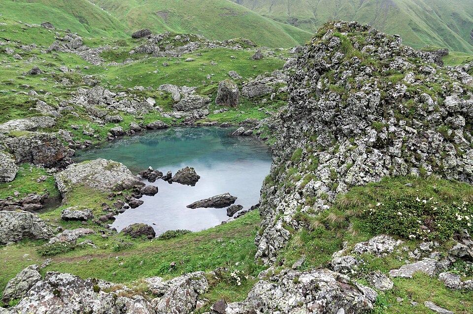 Abudelauri LakesPhoto: Vyacheslav Argenberg, CC BY 4.0
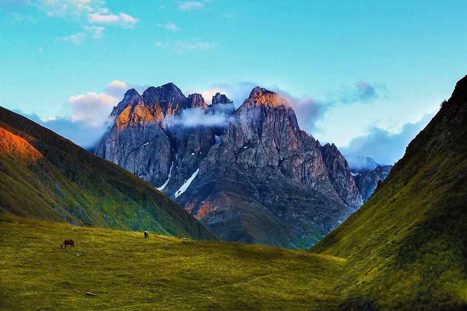
Chaukhi is the jagged limestone massif that rises straight above Juta, often compared to the Dolomites. The pass crosses its southern shoulder at about 3,340 m and links two different worlds: the Khevi valley of Kazbegi, and Khevsureti, the remote land of tower villages to the east. On the far side lie the Abudelauri lakes, three small tarns with strikingly different colours, fed by snow and springs under the Chaukhi walls.
Strong hikers do the whole crossing in one day of 8 to 10 hours. We prefer two: a hard first day over the pass to camp by the Green Lake, and a short second morning to the White Lake and down to Roshka. That leaves time for the lakes in good light and avoids racing an afternoon storm on the pass.
Go this way round, west to east. Juta is higher than Roshka by around 150 m, the climb from the Juta side is longer but gentler, and the steep loose slope lies on the Khevsureti side, which is easier to descend than to climb.
Highlights
- Walking under the 3,800 m Chaukhi towers from Juta
- The view east from the pass into the folded ridges of Khevsureti
- Three Abudelauri lakes in green, blue and milky white
- Morning light on the Chaukhi wall from the lake camp
- Ending in a quiet Khevsur village instead of a tourist town
Trail facts
Last checked Oct 2026 by the Maspindzeli team. Mountain conditions change: ask us before you go.
Is this right for you?
Three quick questions for a friendly second opinion. Nothing is sent anywhere.
Stage by stage
| Day | From → to | Distance | Up | Down | Hours | Highest |
|---|---|---|---|---|---|---|
| 1 | Juta → Chaukhi Pass | 7.5 km | +1,190 m | −0 m | 4.5-5.5 h | 3,340 m |
| 1 | Chaukhi Pass → Abudelauri Green Lake | 4.5 km | +0 m | −740 m | 2-2.5 h | 3,340 m |
| 2 | Abudelauri Green Lake → Roshka | 6 km | +90 m | −620 m | 2.5-3.5 h | 2,850 m |
01Juta to the Chaukhi PassJuta → Chaukhi Pass · 7.5 km · 4.5-5.5 h
Leave Juta on the main valley path, passing the Fifth Season hut after about an hour, with the Chaukhi towers ahead. Continue up the valley floor past the small Chaukhi lake toward the foot of the massif. Here the path turns right and climbs steeply onto a grass and scree slope, then into a long rocky gully that leads to the saddle. The final 400 m of ascent are on loose stones, often with snow patches until August. Take water at the last stream before the climb.
01Chaukhi Pass to the Green Lake campChaukhi Pass → Abudelauri Green Lake · 4.5 km · 2-2.5 h
The descent on the Khevsureti side starts very steep on fine scree and grit, which slides underfoot. Take it slowly, keep the group close so nobody dislodges stones onto others, and use poles. After the first 300 m the slope eases into meadow and the path drops into the Abudelauri valley. Camp near the Green Lake, at about 2,600 m, or continue to Roshka if you are fast and the day is young.
02White Lake detour and down to RoshkaAbudelauri Green Lake → Roshka · 6 km · 2.5-3.5 h
Before breakfast, walk up to the White Lake under the Chaukhi wall, about 1.5 km further and 250 m higher, and come back the same way (add 1.5 to 2 hours and about 3 km; not counted in the totals). Then visit the small Blue Lake below the Green Lake and follow the clear path down the Abudelauri valley through pasture and birch to Roshka, a village of stone houses on a slope above the Roshkistskali.
Practical information
Getting there
Juta is about 20 km from Stepantsminda: 10 km south on the Military Road to Sno, then up a narrow side valley. The access road was damaged in June 2025, and in 2026 the last stretch before the village was still not considered safe for ordinary cars, so expect to walk the final 2 to 3 km or use the seasonal shuttle that replaced the old private van service. A taxi from Stepantsminda to the road end costs from about 60 GEL (about $22) one way in 2026. The road usually opens for the season in June. Juta parking, where open, costs about 10 GEL (about $4) a day.
Getting back
Roshka has no public transport. Arrange a pickup in advance: a car from Roshka to Tbilisi takes about 3.5 hours via Barisakho and Zhinvali and costs about 280 to 380 GEL (about $105 to $140) in 2026. Driving back to Stepantsminda means going all the way round via Zhinvali and the Military Road, 4 to 5 hours. The twice-weekly Shatili to Tbilisi minibus passes the Roshka turn-off on the main Khevsureti road, a few kilometres below the village, but its times change each season.
Water
Plenty on day 1 up to the head of the Juta valley: the river and side streams. From the last stream below the pass to the Abudelauri lakes there is none, about 3 to 4 hours, so fill 2 litres before the climb. The lakes and the stream below them supply water on day 2. Treat everything, because sheep and cattle graze both valleys.
Phone signal
Patchy in Juta, good near the Fifth Season hut, gone in the upper valley and on the pass. On the Khevsureti side there is usually no signal until Roshka, and even there it is weak. Carry an offline map; a satellite messenger is worth it for small groups.
Nearest help
Juta has guesthouses and the Fifth Season hut; Roshka has a few guesthouses. Stepantsminda clinic is about 20 km from Juta. From Roshka the nearest medical help is in Barisakho or Zhinvali, then Tbilisi. Call 112; rescue on the pass may need a helicopter and can take hours.
Permits
No permit or fee. The route lies inside the wider Kazbegi and Khevsureti mountains but outside the restricted border strip. Carry your passport, as police sometimes check on the Roshka road.
Gear and safety
What to bring
- Boots with ankle support and a stiff sole for scree
- Trekking poles, essential on the Khevsureti descent
- Tent, mat and a sleeping bag good to about minus 5 degrees C for the lake camp, unless you cross in one day
- Stove and fuel: there is no firewood above Roshka (buy gas in Tbilisi or Stepantsminda)
- Waterproof jacket and trousers, warm hat and gloves
- Water filter or tablets and capacity for 2 litres
- Microspikes in July if snow remains in the gully
- Offline map and a power bank
Stay safe
- Be over the pass by about 13:00. Afternoon thunderstorms are frequent in July and August, and the gully and saddle are the worst places to be caught by lightning.
- Rockfall: on both sides of the pass, move one at a time through the steepest sections and never stand directly below another walker.
- Snow in the gully before late July can be hard and slippery in the morning; turn back if you lack microspikes and experience.
- Large guard dogs live with the flocks near the Abudelauri lakes and in the Juta valley. Walk calmly past the flock at a distance, do not run, and call out to the shepherds if a dog comes close.
- Fog can hide the path on the Khevsureti descent. Note the line of the trail from the top before you start down.
- For an emergency dial 112. From the pass you may get a signal by moving to the highest point; elsewhere you may need to walk out.
- One long day: Juta to Roshka in 8 to 10 hours with a light pack, arranging the pickup for the evening.
- Day hike from Juta: walk to Fifth Season and the Chaukhi lake and back, about 10 to 12 km and 400 m up, 4 to 5 hours, difficulty 2. This is the right choice in June or when the pass is in cloud.
- From Roshka only: walk up to the Abudelauri lakes and back, about 14 km and 800 m of ascent, a good day if you are staying in Khevsureti.
- Longer: from Roshka continue to Shatili, or make a 2-day crossing from Juta through the Arkhoti valley to Roshka.
- Bad weather swap: Truso valley stays lower and safer; in rain, the Gveleti waterfall walk near the Dariali gorge is short and close to the road.
Emergency number in Georgia: 112. Tell your guesthouse your plan before you set off.
Places on and near the route
Tours that include this trail
Juta to Roshka over the Chaukhi Pass and the Abudelauri Lakes: FAQ
How high is the Chaukhi Pass?
About 3,340 m. Published figures range from 3,338 m to 3,400 m depending on the map.
Can I cross the Chaukhi Pass without a guide?
Experienced hikers do it every summer in good weather. Take a guide if you have not walked steep scree before, in early July while snow remains, or if the forecast is unsettled.
Can horses carry our bags over the pass?
Yes, local horsemen in Juta take packs over to the Khevsureti side in summer; book a day ahead. The horse route is longer than the footpath in places.
How do I get back from Roshka?
Book a driver in advance. There is no bus to the village, and phone signal to call someone from the lakes is unreliable.
Last checked Oct 2026 by the Maspindzeli team. Mountain conditions change: ask us before you go.